


lozere rieutort 40k

ophness
User
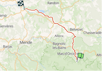

Length
37 km

Max alt
1436 m

Uphill gradient
964 m
Km-Effort
51 km

Min alt
1054 m

Downhill gradient
1169 m
Boucle
No
Creation date :
2020-07-11 15:14:14.534
Updated on :
2021-05-05 07:43:58.968
4h25
Difficulty : Difficult

FREE GPS app for hiking
 SityTrail
IGN / Geographical institutes
SityTrail Plus
The world is yours!
About
Trail Horseback riding of 37 km to be discovered at Occitania, Lozère, Mont Lozère et Goulet. This trail is proposed by ophness.
Positioning
Country:
France
Region :
Occitania
Department/Province :
Lozère
Municipality :
Mont Lozère et Goulet
Location:
Mas-d'Orcières
Start:(Dec)
Start:(UTM)
559450 ; 4922148 (31T) N.
Comments